


Details
| Feature | GS18 I + UHF400 | GS18 I + UHF900 | GS18 T + UHF400 | GS18 T + UHF900 | GS18 + UHF400 | GS18 + UHF900 |
| Model Type | Imaging | Imaging | Tilt | Tilt | Standard | Standard |
| Camera (Visual Positioning) | ✔ | ✔ | — | — | — | — |
| Tilt Compensation (IMU) | ✔ | ✔ | ✔ | ✔ | — | — |
| LTE (Network RTK) | ✔ | ✔ | ✔ | ✔ | ✔ | ✔ |
| UHF Radio | UHF400 | UHF900 | UHF400 | UHF900 | UHF400 | UHF900 |
| GNSS Channels | 555 | 555 | 555 | 555 | 555 | 555 |
| Position Rate | 20 Hz | 20 Hz | 20 Hz | 20 Hz | 20 Hz | 20 Hz |
| RTK Capability | Unlimited | Unlimited | Unlimited | Unlimited | Unlimited | Unlimited |
| Raw Data Logging | ✔ | ✔ | ✔ | ✔ | ✔ | ✔ |
| Best Use Case | Visual positioning & mapping | Visual positioning (longer radio range) | No pole leveling needed | Tilt + long-range radio | Standard surveying | Standard + long-range radio |
Features
Leica GS18 GNSS RTK Rover
- Regular price
- $23,230.00
- Sale price
- $23,230.00
- Regular price
-
Shipping calculated at checkout.
Download Product Spec Sheet
Free Shipping!
This item qualifies for free shipping within the continental U.S.


Engaging software
The Leica GS18 T is accompanied
with the revolutionary Captivate
software, turning complex data into
the most realistic and workable 3D
models. With easy-to-use apps and
familiar touch technology, all forms
of measured and design data can
be viewed in all dimensions. Leica
Captivate spans industries and
applications with little more than a
simple swipe, regardless of whether
you work with GNSS, total stations
or both.

Seamlessly share data among all your instruments
Leica Infinity imports and combines
data from your GNSS RTK rover, total
station and level instruments for one
final and accurate result. Processing has
never been made easier when all your
instruments work in tandem to produce
precise and actionable information.

Customer care only a click away
Through Active Customer Care (ACC),
a global network of experienced
professionals is only a click away
to expertly guide you through any
challenge. Eliminate delays with
superior technical service, finish jobs
faster and avoid costly site revisits
with excellent consultancy support.
Control your costs with a tailored
Customer Care Package (CCP), giving
you peace of mind you are covered
anywhere, anytime.

GNSS TECHNOLOGY & SERVICES
Self-learning GNSS
Leica RTKplus – Adaptive on-the-fly satellite selection
HxGN SmartNet Global
Pro Network RTK and unlimited worldwide RTK bridging and PPP service
HxGN SmartNet+
Network RTK and RTK bridging service
HxGN SmartNet PPP
Unlimited worldwide RTK bridging and PPP service
Leica SmartCheck
Continuous check of RTK solution, Reliability 99.99%
Signal tracking
GPS | GLONASS: L1, L2, L2C, L5 | L1, L2, L2C, L3
Galileo | BeiDou: E1, E5a, E5b, AltBOC, E6 | B1I, B1C, B2I, B2a, B3I
QZSS | NavIC: L1, L2C, L5, L62 | L5
SBAS | TerraStar: WAAS, EGNOS, MSAS, GAGAN | L-Band, IP
Galileo | BeiDou: E1, E5a, E5b, AltBOC, E6 | B1I, B1C, B2I, B2a, B3I
QZSS | NavIC: L1, L2C, L5, L62 | L5
SBAS | TerraStar: WAAS, EGNOS, MSAS, GAGAN | L-Band, IP
RAIM
Receiver Autonomous Integrity Monitoring: detection and elimination of faulty satellite signals
Number of channels
555 (more signals, fast acquisition, high sensitivity)
MEASUREMENT PERFORMANCE & ACCURACY1
RTK Initialisation Time
Typically 4 s
Real-time kinematic – Single baseline
Hz 8 mm + 1 ppm | V 15 mm + 1 ppm
Real-time kinematic – Network RTK
Hz 8 mm + 0.5 ppm | V 15 mm + 0.5 ppm
RTK bridging
Up to 10 min bridging of RTK outages – Hz 2.5 cm | V 5 cm
PPP
Convergence to full accuracy: 10 min
Re-convergence: <1 min – Hz 2.5 cm | V 5 cm
Re-convergence: <1 min – Hz 2.5 cm | V 5 cm
Post processing
Static (phase) long observations: Hz 3 mm + 0.1 ppm | V 3.5 mm + 0.4 ppm
Static / rapid static: Hz 3 mm + 0.5 ppm | V 5 mm + 0.5 ppm
Static / rapid static: Hz 3 mm + 0.5 ppm | V 5 mm + 0.5 ppm
Code differential DGNSS
Hz 25 cm | V 50 cm
COMMUNICATIONS
Communication ports
Lemo | USB | RS232 | Bluetooth® v4.0 (BLE & BR/EDR), class 1.5 | WLAN 802.11 b/g/n
Protocols
RTK: Leica, Leica 4G, CMR, CMR+, RTCM 2.2, 2.3, 3.0, 3.1, 3.2 MSM
NMEA: 0183 v4.00, v4.10, Leica proprietary
Network RTK: VRS, FKP, iMAX, MAC (RTCM SC 104)
NMEA: 0183 v4.00, v4.10, Leica proprietary
Network RTK: VRS, FKP, iMAX, MAC (RTCM SC 104)
Built-in LTE modem3
LTE: 20,8,3,1,7 | 1,2,3,4,5,7,8,12,13,18,19,20,26,28,38,40,41,66
UMTS: 13,17,5,4,2 | 19,3,1
GSM: 900,1800 | 850,900,1800,1900 MHz
UMTS: 13,17,5,4,2 | 19,3,1
GSM: 900,1800 | 850,900,1800,1900 MHz
Built-in UHF modem4
403–473 MHz, 902–928 MHz (license-free NA), up to 28800 bps, max 1W output
GENERAL
Field controller & software
Leica Captivate, CS20, CS30, CC180, CC200
User interface
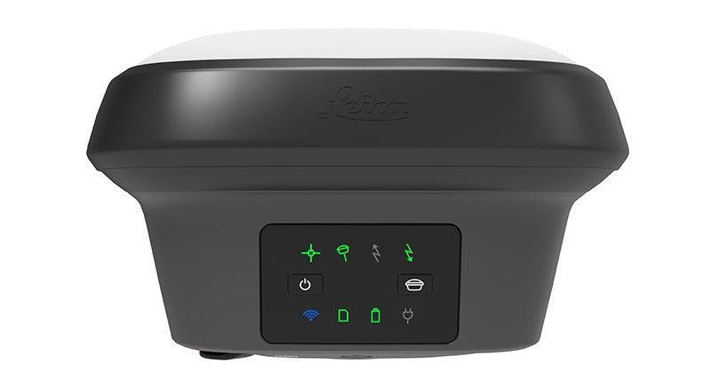
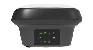
Buttons and LEDs: On/Off, 8 status LEDs; Web server for full status/config
Data recording
Internal 4 GB + SD card; Leica raw & RINEX @ up to 20 Hz
Power management
Internal battery: 2.8 Ah / 11.1 V
External: 12 V DC nominal (10.5–26.4 V range)
Typical run time: up to 8 h
External: 12 V DC nominal (10.5–26.4 V range)
Typical run time: up to 8 h
Weight & dimensions
1.20 kg / 3.50 kg (rover), 173 x 173 x 109 mm
Environmental
Temp: –40 to +65°C (operating), –40 to +85°C (storage)
Drop: survives 2 m fall
IP66/IP68 dust & water
Vibration & shock: MIL STD 810G compliant
Humidity: 95% non-condensing
Drop: survives 2 m fall
IP66/IP68 dust & water
Vibration & shock: MIL STD 810G compliant
Humidity: 95% non-condensing
TILT COMPENSATION UPGRADE
Function
Real-time kinematic tilt compensation for increased speed and traceability
Notes
Calibration-free, immune to magnetic disturbance
Not for static control points
Additional uncertainty: < 2 mm + 0.3 mm/° tilt (down to 30°)
Not for static control points
Additional uncertainty: < 2 mm + 0.3 mm/° tilt (down to 30°)
LEICA GNSS RECEIVERS COMPARISON
GS18 I
GS18 T
GS18
GS16
GS05
GS07
GS10
GS25
Signal Tracking
✔ across all models (frequencies vary)
Imaging Functionality
✔
✗
✗
✗
✗
✗
✗
✗
Tilt Compensation
✔
✔
✗
By upgrade
✗
Up to 30°
✗
✗
Single Baseline RTK
8mm + 1ppm
8mm + 1ppm
8mm + 1ppm
10mm + 1ppm
10mm + 1ppm
10mm + 1ppm
8mm + 1ppm
8mm + 1ppm
Network RTK
8mm + 0.5ppm
8mm + 0.5ppm
8mm + 0.5ppm
10mm + 0.5ppm
✗
10mm + 0.5ppm
8mm + 0.5ppm
8mm + 0.5ppm
SmartNet Global (PPP)
2.5cm
2.5cm
2.5cm
2.5cm
✗
2.5cm
2.5cm
2.5cm
Static
3mm + 0.1ppm (horizontal), 3.5mm + 0.4ppm (vertical)
Static & Rapid Static
3mm + 0.5ppm (horizontal), 5mm + 0.5ppm (vertical)
Reliability
99.99%
Data Logging / Event / PPS
✔ / ✔ / ✔
✔ / ✔ / ✔
✔ / ✔ / ✔
✔ / ✔ / ✔
✔ / ✗ / ✗
✔ / ✗ / ✗
✔ / ✔ / ✔
✔ / ✔ / ✔
Controller
External
External
External
MicroSD
Internal
Internal
Controller Internal
Internal
Interfaces
2 / 8 / ✔
2 / 8 / ✔
2 / 8 / ✔
2 / 7 / ✗
1 / 3 / ✗
1 / 3 / ✗
2 / 10 / ✔
2 / 10 / ✔
Operating Temp
-30°C to +65°C
-40°C to +65°C
-40°C to +65°C
-40°C to +65°C
-30°C to +65°C
-40°C to +65°C
-40°C to +65°C
-40°C to +65°C
Weight (w/ battery)
1.25 kg
1.23 kg
1.26 kg
0.93 kg
0.75 kg
0.70 kg
1.20 kg
1.84 kg
Operating Time (UHF)
8 h
7 h / 5 h
7 h / 5 h
7 h / 5 h
10 h / 10 h
7 h
14 h
14 h / 12 h
Operating Time (internal)
6 h
6 h
6 h
6 h
—
—
—
13 h