 Loading... Please wait...
Mon-Thu 7am-5pm / Fri 7am-3pm CST
1-708-482-8888
5255 Dansher Road Countryside, IL 60525

Pages
- Home
- GNSS / GPS
- Survey Receivers
- Leica GS18 I
Categories

Leica GS18 I

Hover over image to zoom
Product Description
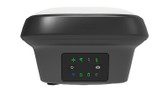
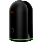
Leica GS18 I - GNSS Rover with Visual Positioning
The GS18 I is the world’s first GNSS RTK rover with integrated Visual Positioning technology.
The Leica GS18 I is a fast, safe and easy to use GNSS RTK rover, with the ability to measure a large amount of remote points from a safe distance.
This is made possible using Visual Positioning technology that is based on the seamless integration of GNSS, IMU and a camera.
The GS18 I gives the ability to measure points either with the pole as a traditional GNSS rover, or by measuring in captured images in the field and in the office, all with survey-grade accuracy.

| | | |


The Leica GS18 I allows surveying professionals to measure previously inaccessible points quickly, easily and accurately. Now they can capture hundreds of points in minutes, safely and efficiently, and decide later which points shall be measured.

GNSS TECHNOLOGY | |||
| Self-learning GNSS | Leica RTKplus | Adaptive on-the-fly satellite selection | |
| SmartLink (worldwide correction service) | Remote precise point positioning (3 cm 2D)1 | ||
| SmartLink fill (worldwide correction service) | Bridging of RTK outages up to 10 min (3 cm 2D)1 | ||
| Leica SmartCheck | Continuous check of RTK solution | Reliability 99.99% | |
| Signal tracking | GPS (L1, L2,L2C,L5), GLONASS (L1, L2, L2c, L32) BeiDou (L1, L2 B1I, B2I, B2a, B3I), Galileo (E1, E5a, E5b, Alt-BOC, E62) QZSS (L1, L2C, L5, L62), NavIC (L53), SBAS (WASS, EGNOS, MSAS, GAGAN), L-Band | ||
| Number of channels | 555 (more signals, fast acquisition, high sensitivity) | ||
| Tilt compensation | Increase measurement productivity and traceability | Calibration-free Immune to magnetic disturbance | |
IMAGING | |||
| Camera | Sensor | Global shutter with 1.2 MP | |
| Field of view (HZ / V) | 80° / 60° | ||
| Frame rate | 20 Hz | ||
| Image group capture | 2 Hz capturing rate | Max. capturing time: 60 s Size of an image group with a 60 s capturing time: appr. 50 MB | |
| Working range | 2 m - 10 m distance to object of interest | ||
| Point cloud | Leica Infinity | Derive point cloud from an image group | |
MEASUREMENT PERFORMANCE & ACCURACY | |||
| Time for initialization | Typically 4 s | ||
| Real-time kinematic (Compliant to ISO17123-8 standard) | Single baseline | Hz 8 mm + 1 ppm / V 15 mm + 1 ppm | |
| Network RTK | Hz 8 mm + 0.5 ppm / V 15 mm + 0.5 ppm | ||
| Real-time kinematic tilt compensated | Topographic points (not for static control points) | Additional Hz pole tip uncertainty typically les than 8 mm + 0.4 mm/° tilt down to 30° tilt | |
| Post processing | Static (phase) with long observations | Hz 3 mm + 0.1 ppm / V 3.5 mm + 0.4 ppm | |
| Static and rapid static (phase) | Hz 3mm + 0.5 ppm / V 5 mm + 0.5 ppm | ||
| Code differential | DPGS / RTCM | Typically 25 cm | |
| Image point measurement | 1-tap measurement in field/office | Typically 3 cm – 5 cm (3D)1 | |
| | |||
Find Similar Products by Category
You Recently Viewed...
Quick Links
What's News
newsletter


Copyright 2024 - Kara Company, Inc. 5255 Dansher Road, Countryside, Illinois 60525. - All Rights Reserved.