 Loading... Please wait...
Mon-Thu 7am-5pm / Fri 7am-3pm CST
1-708-482-8888
5255 Dansher Road Countryside, IL 60525

Pages
Categories
News
Leica Zeno Mobile One - iOS is where it's at!
Posted on Aug 16th 2023
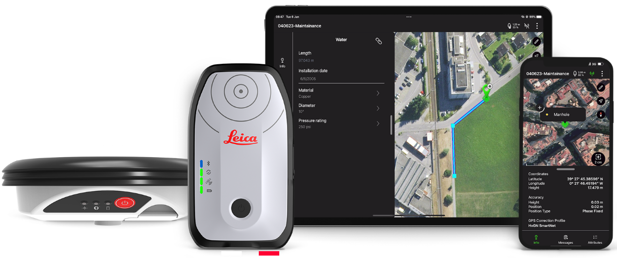

iOS compatibility.
Leica Zeno Mobile One is an easy-to-use app for collecting high-accuracy GNSS measurements, visualising and sharing geospatial data. Connect the Leica Geosystems GNSS devices to utilise high-accuracy data collection. The software runs on iPad and iPhone, designed with a simple and intuitive user interface and workflows with minimum training required.

Simplify your data collection.
Interaction with Zeno Mobile One is simple and intuitive, providing advanced functionality without the need for extensive training. The Zeno Mobile One App imports and exports data easily through the cloud services and supports a range of data formats. The multi-touch functionality ensures an easy map orientation in the App. Connect to HxGN SmartNet to ensure centimetre accurate GNSS measurements.

Seamless data integration.
Zeno Mobile One saves you time in the field by enabling you to capture more data quicker. The new software allows the set-up of on-the-fly data collection without the need for other softwares. Capture multiple features at the same time by using the multi-collect function and link and synchronise your data with the Esri ArcGIS Online platform.
ReIL-NET Mountpoint Changes
ReIL-NET Network SubscribersWe are expanding our mountpoint offerings to make room for new constellations and frequency tracking for compatible rovers. We have also split out categories of mountpoints on to different ports to make sorting and finding your desired mountpoint more user friendly. In order to view a desired list your network port must be [...]
ReIL-NET Upgrade
ReIL-NET UpgradeExpanded Satellite Coverage Over the past year we have been adding upgraded stations and more reliable installations. With the addition of our most recent upgrades we are pleased to announce coverage for GPS (L1, L2, L2C, L5), Glonass (L1, L2, L2C, L32), Galileo (E1, E5a, E5b, Alt-BOC, E62). Rovers with compatible equipment utilizing this [...]
Measure what you see
Are you ready for a change?Whether you need to document the position of the utilities, to survey an area or document a crash scene, inaccessible places can pose challenges for safety and productivity.Imagine the power to…... measure hundreds of points in minutes… measure obstructed points… measure inaccessible places… measure across busy street… capture the whole [...]
Ready to get your Indiana PLS license?
Do you want to get licensed in Indiana but still need another surveying course? Parkland College has a convenient solution for you! Make just three weekend visits to Parkland's Campus in Champaign, perform your assignments online, and you’ll earn the basic engineering credits accepted by Indiana.This fall, we'll launch a new course: SRV 239 - Land Development Design. This class will include [...]
ReIL-NET Server IP Change - ACTION REQUIRED
This message is for all ReIL-NET Subscribers and users of the GPS network. On January 1st, 2019 ReIL-NET will be switching providers which will subsequently change our address for the RTK correction service. In order to maintain RTK corrections the server IP on your rovers will need to be updated. Instructions for Leica Zeno, Viva, and Captivate variants [...]
Quick Links
What's News
newsletter

Copyright 2024 - Kara Company, Inc. 5255 Dansher Road, Countryside, Illinois 60525. - All Rights Reserved.